

Aerial Search & Rescue Support - Built for Australia's Toughest Conditions
When time is critical, our drone-assisted search and rescue services provide fast, efficient, and reliable aerial support for emergency situations.
Outfitted with high-resolution thermal imaging and zoom cameras, our drones can locate missing persons in dense bushland, rugged terrain, or low-visibility conditions — day or night.
We work alongside emergency services, rural property owners, and land communities, providing the ability to cover large areas quickly and safely. Our aerial systems detect heat signatures, movement and distress signals that might otherwise go unnoticed from the ground, ensuring nothing critical is missed when lives are on the line.
We Work With You, Not Around you.
Our drone operators are experienced in working alongside fire services, SES, Police and rescue units. Whether we deploy ahead of a cyclone, after a bushfire, or during a flood emergency, we integrate seamlessly into your operational structure — offering real-time aerial intelligence when and where you need it most
Contact us today to discuss operational support, arrange a live demo, or request standby availability for your region.
HoverHawk — Eyes in the Sky, Support on the Ground
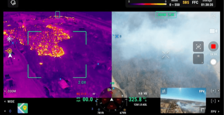

Thermal Imaging
Our drones are equipped with advanced high- resolution thermal sensors capable of detecting even subtle heat signatures through thick bushland, smoke, darkness, and flood debris. This allows responders to locate missing persons, injured animals, or active fire hotspots that are invisible to the naked eye. In fire conditions, thermal imaging provides critical data on fire behaviour and spread, helping teams proactivly address risks before the escalate.
GPS Location Pinpointing
Once a person, object of threat is identified, our drones can immediately mark precise GPS coordinates and transmit them to both ground crews and central command. This feature enables accurate, real-time navigation, reduces search time, and ensures coordinated response efforts. These geotagged markers can be overlaid on live maps, enhancing documentation and facilitating multi-agency collaboration during large-scale emergencies.


Live Multiscreen Streaming
Our systems offer secure, real-time video streaming that can be viewed simultaneously across multiple devices, including mobile units, command centre monitors, and incident response teams in the field. Whether managing a fireground, flood zone, or SAR operation, this technology ensures that all teams are operating with the same up-to-the-minute aerial intelligence, improving decision-making, resource allocation, and safety.
Coverage of Large Areas, Fast
Drones can cover kilometres of terain — including remote bushland, rugged mountains, coastal areas, or floodplains — in a fraction of the time required by foot or vehicle. With high-speed deployment and extended flight times, our systems enable rapid aerial surveys, ensuring that critical areas are assessed quickly and that search efforts remain focused and effective.


Fire Tracking & Hotspot Detection
With thermal sensors and live mapping overlays, our drones can monitor bushfire activity in real time, detect hotspots and flare-ups, and support strategic decisions on where to deploy personnel and resources. Aerial fire tracking gives incident commanders a dynamic overview of the fire front and can identify threats to infrastructure, wildlife, or communities before they become visible on the ground.
Operation over Floodwaters
Our drones are uniquely suited to safely operate above floodwaters, accessing otherwise unreachable areas. From locating isolated individuals on rooftops or vehicles to identifying breaches, hazards, and waterflow patterns, our aerial support is vital for guiding swift-water rescue teams, planning safe entry points, and assessing flood damage in real time — without risking additional personnel.


Radio Operations Knowledge & Integration
Our operators have a strong working knowledge of radio communication protocols and emergency service radio regulations, allowing for effective coordination with ground crews and command centres. We are trained in the practical use of UHF/VHF radio systems and understand the importance of maintaining clear, disciplined communication during active operations. This ensures smooth integration into existing communication networks, reduces confusion in high-pressure scenarios, and supports safer, more efficient multi-agency collaboration.