

Our Equipment
We operate with the latest in professional-grade drone technology, ensuring every job — from inspections to photography and search and rescue — is executed with precision, clarity, and safety. Our fleet includes drones equipped with:

High-resolution Imaging
Our drones are equipped with industry-leading cameras that capture ultra-high-resolution photos and 4K+ video, ensuring every detail is crisp, clear, and usable. Whether documenting infrastructure, capturing art-style landscapes, or monitoring project progress, this level of quality allows for professional-grade results and close inspection — even when zoomed in.
Because detail matters — especially when decisions depend on it
Powerful Optical Zoom up to 200X
Access hard-to-reach places without ever leaving the ground. Our drones feature powerful optical zoom capabilities, allowing us to closely inspect towers, roofs, or other elevated structures safely from a distance. This ensures precision in asset inspections and surveillance tasks, all while maintaining a safe operating environment.
Get closer without compromise — see more, safely.


Advanced Thermal Imaging
With integrated thermal sensors, our drones can detect heat variations that are invisible to the naked eye. This is essential for identifying electrical faults, building inefficiencies, pest animals, or missing persons in low visibility. We use high-sensitivity thermal cameras to provide fast, accurate, and reliable results in critical operations.
See the unseen — thermal insight from above.

GPS-Stabilized Flight Systems
Our drones utilize advanced GPS and IMU stabilization for smooth, steady flight even in challenging conditions. This ensures high-quality data capture, precise flight paths, and safe operation around sensitive environments or infrastructure. Whether mapping, filming, or scanning, flight accuracy is the foundation of our service.
Stable, secure, and surgically precise flight control.

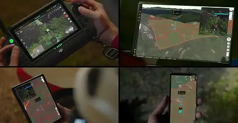
Real-Time Data Transmission
We provide live video feeds and real-time data transmission for clients who need to monitor inspections, searches, or aerial surveys as they happen. This enables faster decision-making, better collaboration, and immediate responsiveness during time-sensitive operations such as search and rescue or emergency assessments.
Stay connected to the sky — as it happens, when it counts.